|
|
|
|
|
|
|
|
|
Ref: Marble, Colorado: City of Stone, by Duane Vandenbusche and Rex Meyers, Copyright 1970.
This is written in a kinda-sorta book report format.
I will only gist the high points of the book. Anybody who has lived in
or visited the Crystal River Valley will enjoy this book. The imbedded
hypertext links will take you to a picture, either from the book or one
of my own. Comments in italics are my own.
-- Glenn A. Smith, October 2004
"The marble deposits surrounding Marble are estimated to be fifty to sixty million years old. The rarity and beauty of the stone makes the geologic history essential to the understanding of the known history and future of the town of Marble, high in the Colorado Rockies." (pg 2) Vandenbusche and Meyers describe the geologic formation of the topography surrounding Marble. Experts estimate the Yule Marble vein will not play out for 100 years. Yule Marble is a compacted limestone base. Varigations in the stone are formed from mixtures with other minerals, the most notable of which are gold, manganese (copper), and pyrite.
Ute Indians lived in the Crystal River Valley. Their first contact was Spanish explorers and missionaries of 1765.
Circa 1830’s mountain men had entered the Crystal River Valley area in pursuit of “black gold,” or beaver pelts. Fort Uncompahgre was built near present day Delta in the late 1830’s.
The first known exploring expedition to reach the valley was in 1860 by Richard Sopris, whom Mount Sopris is named for. (If you have driven up the Roaring Fork Valley from Glenwood Springs to Carbondale you will have seen Mt. Sopris, which is rather prominent in the landscape.) The Crystal River was called Rock Creek, until 1886.
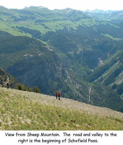
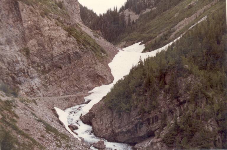
Several documented survey and expeditionary parties entered the area. In 1873 a road was built from the Crested Butte area to Rock Creek over Schofield Pass. Present day Crystal City is nestled at the fork in the river at the base of the pass. (Still today, Schofield Pass and Devils Punchbowl are a challenge to four-wheel drive vehicles. However, once past the Devils Punch Bowl the road smoothes out and it’s a very nice day ride to Crested Butte, with a fishing/picnic stop at Emerald Lake. The Devils Punchbowl and portions of the road between Crystal and Marble have taken their toll in human life. Caution when traveling in the area cannot be stressed enough. If you do go to Devils Punchbowl be prepared. You have to back up nearly 1/2 mile to the nearest turnout to return to Crystal. From circa 1970 to about 1988 the Devils Punchbowl was blocked by a huge snowdrift, which came close to becoming a glacier. Occassional 4-wheelers made attempts to get through, none successful until the snow finally melted.)
Circa 1880 the Ute Indians were moved to the desert Uintah reservation in Northeastern Utah. This is when the development history of Marble, Colorado begins and the end of Chapter One. Local lore includes the tale of some Ute braves attempting to start a forest fire before leaving the valley. They were caught in the act by local residents. The Utes placed a curse on the valley such that any enterprise attempted by the white man would be doomed to failure.
During the period 1873-1893 Yule Marble was discovered, and prospectors searched for silver, lead, gold, copper and zinc. The town of Schofield was formed (a ghost town today, about 4 miles from Crystal City). Residents found a hard life -- long winters, inaccessible ore, and lack of transportation. There was the first report of mud slides, endemic to the Crystal River Valley and especially Marble. The town of Clarence was founded in 1881 at the junction of Carbonate Creek and Rock Creek. The Beaver Lake Lodge is now in this area.
The marble deposit was "rediscovered" by George Yule in 1874. Yule Creek still bears his name, and subsequently Yule Marble. In 1887, specimens of Yule Marble were tested for hardness and quality. Test results showed Yule Marble had a crushing point of 14,500 pounds per square inch -- harder than any marble on record, including the famed deposits of Carrara, Italy. In 1886 John Osgood secured claims in the Yule Creek valley, and in 1890 the stone began to be quarried for profit. Osgood is considered the father of the Yule Marble, but Col. C.F. Meek made it famous in later years.
In 1895 Colorado Yule marble was selected as the stone to be used in construction of the state capitol in Denver. “This started an era of quarrying the stone, for no marble discovery in American history had ever possessed the quantity and quality of the Yule marble.” (This statement is true even today.)
Mineral deposits discovered in the area include lead, zinc, slate, silver, gold and copper. Coal was also discovered but largely inaccessible. Crystal City was settled in the 1880's based on silver and lead discoveries, had a population of as much as 400, and declined in the early 1900's. In June 1899 the town of Marble was incorporated. At its peak Marble had a population of as much as 3,000.
The quarry was carved into the cliff of white marble on White House Mountain. Through four openings men entered the quarry to slice out the marble. Drills, hoists and channeling machines were operated by electric power generated at the electric plant on the Crystal River below. During the first years of operation, the marble was transported from the quarry to the finishing mill by means of horse-drawn wagons and sleds. (pg 25)
By 1907 Marble boasted a community of 700+ people. The town of Marble was booming… town lots that could not be given away a year previous were selling at $35.00 to $250.00. (Today you can safely add two or three zeros to that amount.) The first telephone was installed in the Colorado-Yule Company office, available to the public for important calls.
Yule marble was used for the interior of the Cuyahoga County and Mahoning County courthouses in Ohio.
In 1908, to improve transportation between the quarry and the mill, the nine horse-drawn wagons were replaced by a huge 110 horsepower steam tractor, originally used to haul timber in California. The tractor, with its eight foot steel wheels, was one of the oddities of Colorado transportation history.
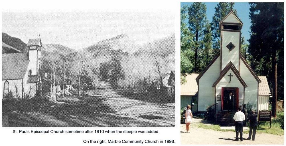
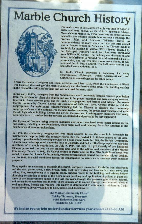
The Marble Community Church was consecrated in 1908. The St. John’s Church building was moved from Aspen to Marble, and renamed St. Paul’s. Today it is non-denominational and popular site for weddings. The church has survived mud slides, snow, and time and looks today much as it did in 1910, when the steeple was added. (The building received a much needed, major rehabilitation in 1961 and 2003. Since a picture is worth a thousand words, here is the Marble Church History posted at the Church door.)
There were 300 men employed by the Colorado-Yule Company and more being hired which made it necessary to build a haphazard “community” of bunkhouses and shacks just west of the quarry site known as Quarry Town, populated mostly by single men. In the winter the men would ski to Marble. In later years, after the electric tram was built (1910), the men would hang on the tram cars and ski back to Quarry Town -- Colorado’s first ski tow. By 1909 marble workers were making $5 to $8 a day and expected to work nine-hour days with considerable overtime, and company houses, fully furnished, at $6 a month.
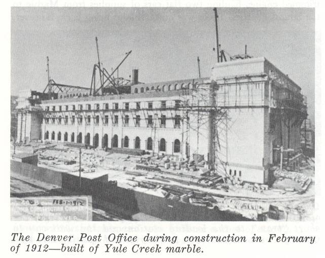
In January 1910 the movie “The Big Bear Hunt” premiered, filmed in Marble. A major labor strike ended the same year, but left the town culturally divided into labor and company factions. Marble was shipped for the construction of the Denver Post Office and the Montana State Capitol.
In late 1914 to 1916 the stone for the Lincoln Memorial in Washington, DC was quarried. The contract called for 36 columns, each 46 feet high, and 7 feet in diameter. 1,800 stones weighing from 15 to 30 tons each were required to achieve the finished product. The columns consisted of marble drums, one upon the other. Forty trains of 15 cars apiece were eventually required to transport the marble to Washington.
From 1916 to 1920, due to Nature (in the form of snow and mud slides), WWI and financial difficulties of the Yule Marble Company, Marble nearly became a ghost town. However, the city once again flourished with the end of the war, successful court battles and reorganization of local the marble industry.
In 1930 the Yule-Colorado Company was awarded the contract to provide marble for the Tomb of the Unknown Soldier. It required 75 men working continually for more than a year to cut the block of marble out of the quarry. When first cut, the block weighed approximately 124 tons, easily the largest piece of marble ever quarried. The block was then rough cut at the quarry to the required dimensions: 14 by 7.4 by 6 feet. The block, when trimmed, weighed 56 tons. In late January, 1931 using a specially constructed derrick, the block was hoisted from the quarry floor, a distance of 125 feet to the opening. A special hand-made rail car and temporary tracks were laid to move the block down the mountain to the mill site. It took 4 days to cover the 3.9 miles. "On November 11, 1932 the great block of Yule Colorado marble was put in place at the Arlington Memorial entrance. It has stood since that time as a monument not only to the Unknown Soldier but also to the little town in the Colorado Rockies which produced it." (2006 update: The original block has succumbed to time and a crack has been detected along its perimeter. A replacement block has been quarried, rough cut, and stored in the marble yard but the final decision to use Yule marble has not been made.)
In 1938 construction of an improved road from Gothic to Marble, via Schofield Pass and Crystal, began. Construction stopped at Devils Punchbowl due to insufficient financing. Four-wheeled vehicles could not pass from Gothic to Marble until 1958.
In August 1941 a mud slide and flash flood down Carbonate Creek, and the closing of the Yule-Colorado Company in December 1941, took the final toll on Marble as a thriving town. In July 1945 another even more massive mud flood occurred. "Practically everything left in Marble was hit by a 30-40 foot wall of water, mud and rocks... Most of the flood signs visible in Marble at the present time are from the 1945 slide."
Regardless the obvious high quality of the Yule Creek marble, it could not remain competitive in the market due to high development, production and transportation costs. Large-scale, commercial development of any other mineral deposit in the area came to the same conclusion.
There were only 24 registered voters in the Marble precinct in 1956. The Marble airstrip and Beaver Lake Lodge were constructed in 1957. In 1958 the Schofield Pass road finally opened to 4-wheel drive vehicles only (boulders, rock slides and washed out bridges had made it impassable since 1928 to all but horses and hikers). In 1962 the Outward Bound School opened in Marble. Thus, an era of tourism started.
Today summer recreation and tourism is the predominate business in the area surrounding Marble. The marble quarry once again started operation in 1991. Much of the development predicted by the authors has not occurred. The Crystal River Valley and Marble remain among the most beautiful areas in the world because of its pristine topography. In the appendix the authors list over 100 buildings built totally or in part from Yule Creek marble.
On a personal note, I remember coming to Marble and Crystal with my parents as a child, circa 1950's. We would tow our 1948 Willys to Marble, and go camping and fishing. I fondly recall the store in Crystal and getting soft drinks out of the the ditch that runs through town, ice cold from being in the water. The store is still there and so is the ditch with soft drinks. Unfortunately, the store in Marble, with its millions of bottle caps nailed to the exterior walls, is no longer in existence.
We once crossed the Crystal River above the town of Crystal and drove our Jeep to the Old Mill. A vestige of the road is still there, but crossing the river is hazardous to the extreme.
The historic, and often photographed, Crystal Mill was built in 1892, to provide compressed air power to the Sheep Mountain Tunnel. In 1973 funding was obtained to pay for a new roof and other repairs to stop the deterioration of this picturesque landmark. Contact the Marble Historic Society, who will gladly accept any and all donations to keep the Old Mill erect.
The loop road through Lead King Basin borders on the Maroon Bells-Snowmass Wilderness area. In fact, from the top of Sheep Mountain you can see Capital Peak, Snowmass Mountain and the Maroon Bells. This 66,000 acre wilderness area has 130 miles of marked trails and contains the largest number of peaks over 14,000 feet in Colorado.